
Aucklandweather
- Updated
- Sunrise:
- Sunset:
22°C

- 27°C20°C
Partly cloudy with a few showers, some heavy with possible thunderstorms. Northerlies.
- 25°C18°C
Showers, becoming more frequent and heavier in the morning, with possible thunderstorms. Localised downpours possible from early afternoon. Northerlies.
- 25°C17°C
Mainly fine, chance of a shower until evening. Westerlies.
For more detailed weather information visit MetService.
Marine Recreational Forecasts - Auckland
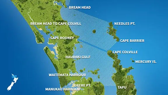
Area Description:
Bream Head to Cape Colville, Hauraki Gulf, Waitematā Harbour, Manukau Harbour
Situation:
A ridge of high pressure over the country weakens today as a Tasman Sea low and its associated warm front move onto central New Zealand. Tomorrow, the warm front stalls over the upper South Island, while a cold front approaches the North Island from the west as the low moves east across central New Zealand. A low over central New Zealand moves slowly eastwards on Friday. A ridge of high pressure moves over the country from the southwest on Saturday, bringing a cooler southerly flow to most places. A large high covers the South Island on Sunday but east to southeast winds remain over the North Island as a low may approach the Island from the north.
Warnings:
Strong wind advisory
Strong wind advisory
Forecasts:
For Bream Head to Cape Colville:
Today: Northerly 15 knots but 20 knots about Colville Channel. Becoming northerly 15 knots everywhere in the evening. Moderate sea about the Channel, easing in the evening. Partly cloudy with fair visibility in the odd shower. Possible thunderstorms.
For Hauraki Gulf:
Today: Northerly 20 knots, easing to 15 knots in the evening. Moderate sea easing in the evening. Partly cloudy with fair visibility in the odd shower. Possible thunderstorms.
For Waitematā Harbour:
Today: Northerly 20 knots, easing to 15 knots in the evening. Moderate sea easing in the evening. Partly cloudy with fair visibility in the odd shower. Possible thunderstorms.
For Manukau Harbour:
Today: Northerly 10 knots. Sea slight. Partly cloudy with fair visibility in the odd shower. Possible thunderstorms. For the west coast: Southwest swell 2 metres easing to 1 metre.
Outlook:
For Bream Head to Cape Colville:
Thursday: Northerly 15 knots but northeast 15 knots about Colville Channel, rising to northerly 20 knots gusting 30 knots west of the Channel in the morning, then to 25 knots gusting 35 knots but northeast 20 knots gusting 30 knots about the Channel in the afternoon. Becoming northwest 20 knots everywhere in the evening. Sea becoming rough for a time in the afternoon and evening west of Colville Channel. Poor visibility in showers. Possible thunderstorms from morning.
Friday: Northwest 20 knots, easing to variable 5 knots in the morning. Becoming southwest 10 knots in the evening. Showers clearing.
Saturday: Southwest 15 knots, turning easterly 15 knots later. Fine. Northeast swell 1 metre dying out.
Sunday: Easterly 15 knots, rising to 25 knots early. A few showers. Easterly swell 1 metre developing.
For Hauraki Gulf:
Thursday: Northerly 15 knots, rising to 20 knots gusting 30 knots in the morning, then to 25 knots gusting 35 knots in the afternoon. Becoming northwest 20 knots in the evening. Sea becoming rough for a time in the afternoon and evening. Poor visibility in showers. Possible thunderstorms from morning.
Friday: Northwest 20 knots, turning southwest 10 knots in the morning. Showers clearing.
Saturday: Southwest 10 knots, turning easterly 10 knots early, rising to 20 knots late. Partly cloudy.
Sunday: Easterly 20 knots. A few showers.
For Waitematā Harbour:
Thursday: Northerly 15 knots, rising to 20 knots gusting 30 knots around midday. Turning northwest 15 knots in the evening. Sea becoming moderate in the morning, easing evening. Poor visibility in showers. Possible thunderstorms from morning.
Friday: Northwest 15 knots turning westerly 15 knots in the morning. Showers clearing.
Saturday: Southwest 10 knots, easing to variable 5 knots early. Becoming easterly 15 knots late. A few showers developing.
Sunday: Easterly 15 knots. Mostly cloudy with a few showers developing.
For Manukau Harbour:
Thursday: Northerly 10 knots, rising to 15 knots in the morning, then to 20 knots gusting 30 knots in the afternoon. Turning northwest 10 knots in the evening. Sea becoming moderate for a time in the afternoon and evening. Poor visibility in showers. Possible thunderstorms from morning. For the west coast: southwest swell 1 metre rising to 1.5 metres.
Friday: Northwest 10 knots, becoming westerly 10 knots in the morning. Partly cloudy. For the west coast: Southwest swell 1.5 metres.
Saturday: Southwest 10 knots, becoming northeast 10 knots late. Partly cloudy. For the west coast: Southwest swell 1 metre.
Sunday: Easterly 15 knots. Occasional rain. For the west coast: Southwest swell 1 metre.
Swell:
Marine Coastal Forecasts - Colville
Forecast:
Wednesday: Northerly 15 knots. Sea slight. Poor visibility in showers. Possible thunderstorms.
Outlook:
Outlook following 3 days:
Thursday: Northerly 15 knots. Sea slight. Poor visibility in showers. Possible thunderstorms.
Friday: Westerly 15 knots.
Saturday: Southwest 10 knots, changing easterly 20 knots later.
Sunday: Easterly 25 knots. Sea rough. Easterly swell becoming moderate.
Marine Coastal Forecasts - Raglan
Forecast:
Wednesday: Northerly 15 knots. Sea slight. Southwest swell 1 metre. Poor visibility in showers.
Outlook:
Outlook following 3 days:
Thursday: Northerly 20 knots, becoming westerly 15 knots in the evening. Moderate sea easing. Long period southwest swell rising to 2 metres. Poor visibility in showers. Possible thunderstorms.
Friday: Northwest 15 knots, turning southwest 15 knots in the afternoon. Moderate westerly swell.
Saturday: Southwest 20 knots, becoming southeast 15 knots but 25 knots south of Kawhia Harbour later. Sea becoming rough in the south. Moderate southwest swell easing.
Sunday: Easterly 20 knots but southeast 30 knots south of Kawhia Harbour. Sea rough in the south.