Barry Benton with the seawall he had built in front of his property. Photo / George Novak
Barry Benton with the seawall he had built in front of his property. Photo / George Novak
In April more than 1500 inner Tauranga harbour landowners were told their properties were at risk from one or more potential sea-level rises over the next 110 years. In the more extreme - and unlikely - scenarios houses could be lost within a few decades. The information came as ashock to some, while others were less concerned. Now some homeowners are calling on councils to do more to help people protect their property. But with kilometres of publicly-owned coastal land and assets, councils have their own concerns.
Updated coastal erosion maps "frightened the hell out of a lot of people", says a Maungatapu retiree told his million-dollar waterfront home could be gone in decades.
Now harbourside homeowners who have spent tens of thousands on erosion defences are calling on councils to make it simpler and cheaper for people to protect their properties from being eaten away by slips and rising seas.
Councils say they are open to process improvements, but also have kilometres of publicly owned coastline and coastal assets to consider.
In April more than 1500 inner harbour landowners were told their properties could be at risk from erosion and land instability linked to sea-level over the next 110 years.
The data came from erosion maps updated in a joint project by the councils for Tauranga and the Western Bay of Plenty that modelled several sea-level scenarios and timelines ranging producing risks ranging from very unlikely (5 per cent) to likely (66 per cent).
Barry Benton said the maps predicted his beloved Maungatapu home of 17 years could be "wiped out" in decades - an assessment he felt was "exaggerated".
He said the maps frightened people, with some fearing property values would be impacted by having the risks noted on property files.
"It's possible but unlikely that my house will be gone in 2030, which I think is a little bit hard to believe ... If a potential buyer sees that, what is that likely to do to the deal?"
He said the risk calculations did not take into account protections installed by homeowners.
He spent $4000 and four years obtaining consent to build a seawall and install drainage on his gently sloping coastal boundary. Construction cost around $40,000.
Barry Benton on the seawall he had built at the bottom of his slope. Photo / George Novak
Unless his neighbours also took action, however, his home would still be vulnerable.
He presented in a Tauranga City Council meeting last week, suggesting a standardised consent process would help others in his situation.
Homeowners in Matua and Welcome Bay agreed councils could do a lot more.
Dr John Gemming, who has lived in Forrester Dr for 39 years, said the new erosion information did not worry him as he had an effective and longstanding concrete seawall, which he was confident any future buyer would take into account.
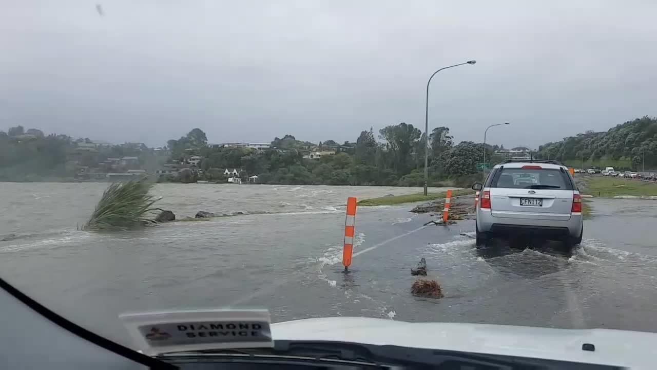
Flooding hits Tauranga
The Wairoa River broke its banks, flooding Te Puna Station Rd, while floodwaters rose around the city during the January 5 storm. ...
Video Player is loading.
Current Time 0:00
/
Duration 0:00
Loaded: 0%
0:00
Stream Type LIVE
Remaining Time -0:00
1x
Chapters
descriptions off, selected
captions settings, opens captions settings dialog
captions off, selected
This is a modal window.
Beginning of dialog window. Escape will cancel and close the window.
End of dialog window.
This is a modal window. This modal can be closed by pressing the Escape key or activating the close button.
NOW PLAYING • Flooding hits Tauranga
The Wairoa River broke its banks, flooding Te Puna Station Rd, while floodwaters rose around the city during the January 5 storm. ...
Peter Pollett, a Manuwai Dv resident of 50 years, has suggested, based on his experience, the Matua Residents' Association rally residents make joint building and resource consent applications.
His old timber seawall was damaged by a log in the monster storm of January 2018, that caused flooding around the city.
He has since spent more than $28,000 designing and consenting a rock seawall for his property that could cost up to $100,000 to construct.
Pollett said it took four months to get the consents, costing just under $9000 in fees alone between the city council and Bay of Plenty Regional Council.
He hoped the Government's Resource Management Act review would improve the process.
Pollett thought the new maps were "scaremongering, to a large degree".
Dr John Gemming. File photo
Campbell Larkin, who led the mapping project for Tauranga City Council, said the council followed regional council and Ministry for the Environment guidelines when it updated the maps.
The idea was not to penalise landowners but to ensure everyone understood the risks and could choose the right mitigation strategies.
The council could not adjust the maps for individual properties but could note erosion mitigation structures on property files by request.
"We appreciate that this is a big topic to take in. Which is why we gave people the opportunity to explore the outcomes ... with our online viewer (increasing understanding of the different scenarios shown), as well as the option to talk to us in person about what this meant for them."
Coastal erosion predictions for Maungatapu, ranging from very unlikely (orange) to likely (lighest yellow). Source / Tauranga City Council
About 35 people took the Tauranga council up on that offer, while three met with the Western Bay council.
Both councils will be writing to residents again this month about new harbour inundation modelling.
Larkin said the council needed to make the consenting process clearer for the public.
The first step was a revised policy signed off for consultation last week that confirmed the council's approach to using public land for private protection structures.
Mark Townsend, acting general manager for integrated catchments at the regional council, said the council was open to improving consenting processes within the confines of the Resource Management Act.
Coastal erosion predictions for Matua, ranging from very unlikely (orange) to likely (light yellow). Source / Tauranga City Council
The council was working with other councils in the region to invest in research on climate change impacts - particularly sea-level rise - and coastal inundation projections.
The information would help communities adapt.
"It is becoming more and more apparent that climate change adaptation will be a significant and potentially costly challenge."
Councils faced challenges of their own to protect public coastal land and assets, with Local Government New Zealand finding up to $14 billion worth of infrastructure from 62 councils may be at risk from sea-level rise.
Simon Anderson, chief executive of Realty Group which operates Eves and Bayleys, said in general, demand for waterfront property in Tauranga remained strong even in areas with land issues.
Realty Group chief executive Simon Anderson. Photo / File
He said property files and LIM reports provided enough information to inform buyers doing their due diligence, and waterfront buyers were usually experienced in the property market.
Jason Eves, a waterfront property specialist with Oliver Road Estate Agents, said all locations had a risk/reward dynamic - whether building on a slope for unobstructed views, or on flat land in a potential liquefaction zone - and each buyer would weight the factors differently.
In most instances, risks could be substantially mitigated through a variety of possible solutions.
"Waterfront living remains both highly desirable and possible."