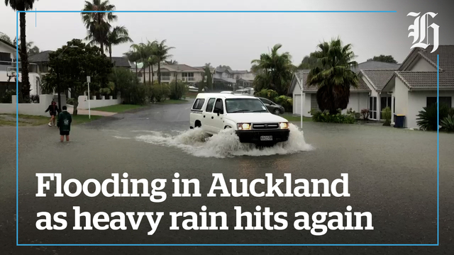
“If thunderstorms do occur, there is a low risk they may produce localised downpours, and possibly a small and very localised tornado.”
“Get your household ready for this evening’s rain,” advised Auckland Emergency Management.
“Clean out gutters and drains to reduce the risk of them overflowing,” it tweeted.
“We will continue to keep you informed as we get intel from MetService.”
There is also an orange heavy rain warning for Marlborough south of Clarence and North Canterbury north of Waikari.
The forecast is for rainfall of 30 to 60mm on top of what has already started to fall in some areas.
The service said a complex trough of low pressure continues to bring heavy rainfalls to the region, and people are being urged to keep up to date with the latest forecasts.
It warned the heavy rain could cause streams and rivers to rise rapidly, with surface flooding and slips possible, making driving conditions hazardous.
The Orange warning will remain in place until 1pm today.
Meanwhile, meteorologists say another complex trough moves onto the North Island tomorrow and watches for heavy rain for Gisborne and Coromandel Peninsula are now in force from 9am tomorrow until 3am on Tuesday.
Tropical low being ‘closely monitored’
Meteorologists are closely monitoring a weather system near Fiji, which has the potential to turn into another tropical cyclone.
But MetService said it is too early to know whether that would happen, and whether New Zealand will be affected.
“There is a tropical low, 8F is the technical name at the moment, that was analysed this morning to the north of Fiji,” said meteorologist Ciaran Doolin.
“There is a low risk today of it forming a tropical cyclone.”
That risk would pick up to “moderate” in the coming days, though.
There was also another low over the Coral Sea, which Doolin described as “poorly organised at the moment” which also had a chance of turning into a tropical cyclone. It would move towards Vanuatu early next week.
But it was still too far off to make solid predictions on either weather system, and their movements.
“We’re talking quite long range now for a system that’s not even being called a tropical cyclone.
“The really long-range projections at the moment have this system kind of moving east of the country a bit, quite far east ... but we need to emphasise a lot of uncertainty. Over the next several days we will have a lot more certainty.”
What was of more immediate concern to New Zealanders was a band of possibly heavy rain moving across the eastern parts of the North Island on Monday and Tuesday.
“That’s probably going to be more significant as far as most people are concerned,” he said.
The flood-ravaged areas of Auckland and Hawke’s Bay, along with the Bay of Plenty, were at low risk of heavy rain, while Gisborne and the Coromandel were at moderate risk of heavy rain, he said.
A “band of moisture” was currently sitting offshore but easterly flows would push that across the east and north areas of the North Island.
“That’s probably the more immediate thing to look out for.”
Meanwhile, the South Island could expect good weather for the next few days, with rain midweek. The West Coast is expected to take the brunt of the weather.
About that time the weather is expected to ease for the North Island, and in the meantime, Wellington was “neither going to be the worst off nor the best off”.
Weather for the week ahead
Doolin said it would be a bit of a “seesaw” across the country next week, with sunshine for the south and rain for the north over Monday and Tuesday, then vice versa.
There was a moderate risk of heavy rain in the Coromandel and Gisborne areas around Monday and Tuesday, and a low risk of heavy rain for Auckland, Bay of Plenty and Hawke’s Bay.
Doolin said there was an easterly flow pushing the band of rain across the northeastern parts of the country.”
That’s probably the more immediate thing to look out for for the North Island,” he said.
Meanwhile, the South Island was “continuing to see largely pretty nice weather” and that was going to carry on for the early part of the week.
“However, they are going to see, in sort of the middle of next week, a front push across them, which means conditions are going to deteriorate for them.”
The West Coast was most likely to be affected, he said.
The North Island weather will start to improve at that time.
“It’s kind of a bit of a seesaw going on.”
Wellington will experience a little bit of everything, he said.


